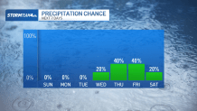

For the second straight week, we’ve dealt with cloudy days and the rain that comes with it. The worst of this week’s rain came on Wednesday, but we still have a storm threat as we head into the weekend.
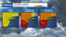
We’re watching out for isolated strong-to-severe storms over the tri-state on Friday and Saturday.
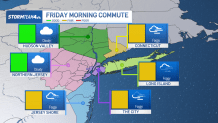
Thursday’s scattered light showers provided a buffer between Wednesday’s soaking rain and Friday’s storms. And despite the fact that Friday’s storms may be impressive, they will also be widely scattered. We’ll start the day dry, so no need to worry about wet roads for the morning commute. Instead, fog may be a problem for the second day in a row.
By late-morning a line of showers and storms will push into west New Jersey. These storms will include pockets of heavy rain along with the potential for damaging wind gusts and even small to medium-sized hail.
As the line of storms advances across the region, it will significantly weaken. By the time it arrives in the city around midday, the heaviest rain will have tapered to showers.
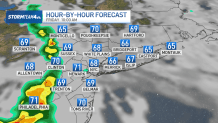
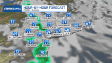
Isolated storms may pop up in the afternoon, but the majority of us will enjoy a mainly dry afternoon and evening. We may even get a peek of sunshine or two!
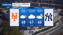
This is fantastic news if you are planning on attending the Subway Series. Friday night’s game is in the evening, after the bulk of the showers and storms. A spotty shower is possible, but a delay in the game is unlikely.
Even if your tickets are for Saturday’s game, a stormy forecast may not turn out so bad. Similar to Friday, Saturday’s severe weather threat will arrive in the morning and be most potent to the west of New York City. Unlike Friday’s storms, though, Saturday’s storms have a better chance of holding together as they move across the area, meaning many of us could still be waking up to periods of heavy rain and gusty wind.
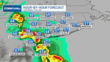
Thankfully, any morning storms that develop are quick-moving and won’t make a mess of the entire day. In fact, by first pitch at 1:05 p.m. the storm threat will be diminished, with only isolated wet weather impacting the area. The storm threat will be completely over when a cold front pushes through Saturday night.
If you’re looking for pristine baseball weather, Sunday is the day. The cold front will have pushed the rain away and sunshine will return.

Even if you’re not a baseball fan, Sunday’s weather is enough to encourage anyone to get outside and enjoy.
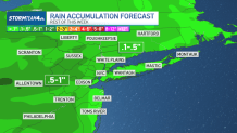
Rain totals through Saturday will be very manageable. The greatest amounts will be confined to our western-most counties, where the strongest storms will set up. Those areas should plan for a half an inch, with some spots getting closer to an inch of rain. Farther east, totals will be closer to a tenth of an inch near the city and even less on Long Island.
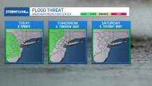
The risk of flooding is generally low. But since it has already been such a soggy start to the month, it does not take much additional rain for flooding to be possible. As a result, those areas with the higher rain totals, primarily to our west, are under a marginal risk for flooding over the next few days.
Once the sun does emerge on Sunday, we’ll enjoy it for several days in a row. Enjoy it, because we’re already looking ahead to another run of wet days as early as the middle of next week.