
With La Niña underway and global temperatures continuing to rise, experts warn of an increased risk of wildfires and severe storms across the country.
Data from the National Oceanic and Atmospheric Administration (NOAA) Climate Prediction Center shows that La Niña conditions are likely to continue through February 2026.
Here’s what that means:
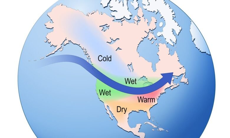
Temperature changes with La Niña
La Niña is part of a natural climate cycle known as the El Niño – Southern Oscillation (ENSO), which varies between phases caused by changes in trade winds and ocean temperatures in the tropical Pacific Ocean. Typically La Niña aligns with a cooler winter and El Niño years are more moderate, but as global temperatures rise the effects of these natural cycles are changing.
Tom Di Liberto, a scientist for Climate Central, a nonprofit science research group, said that during La Niña, in an area that tends to be drier than average, “climate change might make that a little bit drier. Where it tends to be a bit wetter than average in the Pacific Northwest, climate change might make that a little bit wetter.”
La Niña causes cooler temperatures and cooler winters since the water is cooling however the last few years of La Niña have been warmer than what El Niño temperatures were a decade ago based on data from Climate Central.
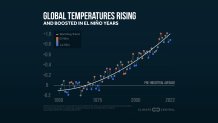
Di Liberto said the steady increase in temperatures is a human-caused phenomenon.
Changes in the sun’s energy and volcanic eruptions also can affect the climate, but Di Liberto said “the sun’s energy has not changed in the last 70 years” and volcanic eruptions have decreased.
Di Liberto said that looking at the data alone from 1970, we would have seen the planet slightly cool, but “rather we’ve seen it warm significantly.” This is because of the rise in greenhouse gases being emitted by human activity.
Precipitation changes with La Niña
A La Niña winter increases the risk of extreme weather events.
During La Niña, the water that is typically moving from east to west is amplified causing warmer waters in the west and cooler waters in the east. This impacts precipitation levels across the globe.
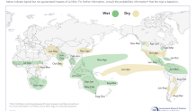
Based on data from the Columbia University Climate School in New York, La Niña typically leads to drier weather in the southern part of the country and wetter weather in the Pacific Northwest and Northeast.
Increased temperatures from global warming have led to a rise in temperatures in the north central Pacific Ocean, which is a cause for concern as La Niña begins to set in this fall.
As ocean temperatures rise, the atmospheric pressure lowers, allowing the air to become denser and capable of holding more moisture. As trade winds pick up the ocean has the potential to become a runway for early season storms.
When looking at impacts in places like Southern California, La Niña can extend what has been a devastating fire season by prolonging the dry conditions through the fall and winter.
In January of last year, Los Angeles experienced severe wildfires fueled by dried out vegetation and strong Santa Ana winds, which blow from Nevada and Utah into Southern California in the fall. According to NOAA “long-term global warming and the development of La Niña contributed roughly equally to making the extreme fire weather conditions more likely and more extreme.”
With La Niña conditions returning for the fall months, and an already dry season underway, the risk of wildfires grows.
How to prepare for La Niña
Di Liberto says that when looking at weather trends, “La Niña and El Niño are just one of many elements that come into play.”
But, Andrew Kruckiewicz of Columbia Climate School says its still essential to understand and track La Niña and El Niño, especially in areas where impacts lead to significant risks and changes in order to prepare.
Rob Mayeda, a meteorologist for NBC Bay Area, contributed to this story.