
March has a way of delivering serious weather whiplash to the tri-state, and this week drives that point home.
After a high temperature of 80 degrees in Central Park on Tuesday – the earliest 80-degree temperature on record for the city – temperatures take a tumble on Thursday. And ahead of the big temperature drop, we’ve got a few storms in the forecast, with isolated severe weather possible.

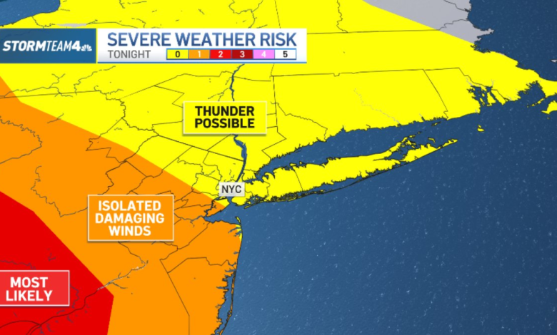
The strongest storms will be southwest of New York City, where Wednesday’s temperatures are warmest and the air is most unstable. For Central and South Jersey, the threat level is a Level 1 (lowest on a scale of 1 to 5). Storms should weaken as they move into cooler air at the coast.

The most likely threat from the strongest storms will be damaging straight-line wind. Small hail is possible, too, but less likely.
Storms are most likely from mid-evening into the overnight. They will move from west to east ahead of an approaching cold front.
A real shock to our system will come on Thursday, when the cold front sweeps through the region and delivers us a wintry feel. Temperatures will start in the 50s and 60s Thursday morning, but quickly drop into the 40s by afternoon.

On top of the temperature tumble, winds will gust up to 30 mph and we’ll get a few light showers moving through the region.
As temperatures drop in to the low 40s and 30s, some of the light showers could mix with snow. But with air temperatures at the surface above freezing and the ground warm from our spring fling earlier in the week, any flakes that fall will melt immediately, so don’t expect any accumulation.


Cold air stays in place through Friday, with some modest warming for the weekend, when we expect high temperatures close to normal – near 50 degrees – under dry skies.
Monday is wet, but the rain is out by St. Patrick’s Day, which will be mostly sunny and chilly.
Here’s a look at the hourly forecast for Wednesday night:
8 p.m.

9 p.m.

10 p.m.
11 p.m.

12 a.m.