We’re blazing hot (and it comes as no surprise)!
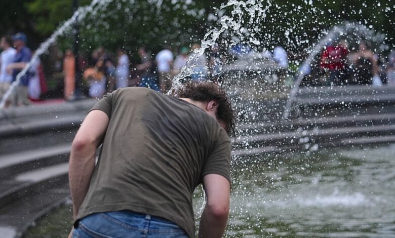
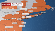
Extreme heat has again enveloped the tri-state area, prompting the National Weather Service to issue heat advisories through Wednesday.
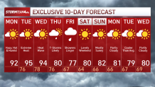
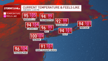
Current temperatures are well above 90 with heat indices near or above 100, and this week is shaping up to deliver the second heat wave of the summer in New York City through mid-week, before a cold front brings relief. Check the latest weather alerts for your neighborhood here.
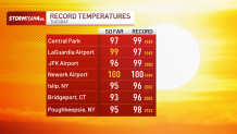
So far on Tuesday, two high temperature records have either been tied or broken so far.
By definition, a heat wave in New York City is three consecutive days with air temperatures reaching 90 degrees or above. But this week’s hot temperatures are coming with brutal levels of humidity, making it more dangerous as “feels like” temperatures top 100 degrees outside.
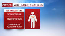
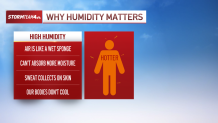
Feels-like temperatures are important because they communicate the combined effect of temperature and humidity on our bodies. When humidity is high, like it is this week, it is much more difficult for our bodies to regulate their temperature and keep us cool.
Under normal circumstances, when we sweat, the sweat pulls heat from our skin and evaporates, cooling us down in the process. But when the air is already full of moisture, it is much harder for sweat to evaporate; instead, the sweat sits on our skin as the body struggles to regulate its temperature.
That’s when the problems begin.
And this sort of heat only gets worse when it persists for several days, like we expect to see this week.
Under these circumstances, our temperatures are not cooling off much, even overnight. Our low temperatures are only dropping into the upper 70s, while the humidity stays comparably high. This means our bodies aren’t getting any sort of relief from the heat.
It is not until Thursday that temperatures moderate, thanks to a cold front. Ahead of the front, we could get storms as early as Wednesday afternoon, but it is not until the front passes on Thursday that the main storm threat arrives, followed by cooler and drier air.
On Tuesday, New York City also issued an air quality advisory until Wednesday after it is predicted it will reach a level orange (which is when the Air Quality Index (AQI) is between 101-150). This level makes the outdoors “unhealthy for sensitive groups and may be unhealthy for those sensitive to air pollution (older adults over 65 or children younger than 14, pregnant individuals, outdoor workers, and those with medical conditions such as heart or lung disease or respiratory issues such as asthma).” However, the risk remains low for healthy people.
Temperatures and humidity will continue to drop through Friday, when we cool by almost 20 degrees. A few showers will linger into Friday, but by the weekend, we are looking at a near-perfect weather picture.
Sunny skies return, but this time without oppressive heat and humidity. Temperatures will sit comfortably in the low 80s while dew points hold in the low 50s. Make plans to get outside this weekend.
It quite literally does not get better than this.