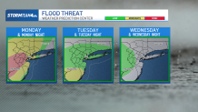
Out of the gate this week, heavy rain and the threat for flash flooding has dominated the weather headlines in the tri-state area.
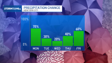
The flood threat diminishes overnight, but the heat and humidity will not let up. And, while they won’t be as numerous as Monday, storms are in the forecast each day this week.
With a decrease in storm intensity, we’re not expecting as big a flood threat after Monday. Similarly, we will manage to stay out of the severe risk for the coming days.
But that does not mean we are looking ahead to a dry forecast. In fact, we are going to see a near daily chance of showers and storms.
Most storms this week will be fueled by daytime heating and increased atmospheric instability in the afternoon. There’s no big weather system coming our way to spark storms and trigger an influx of drier air from the north. Instead, we are stuck with a southerly wind flow this week, which will facilitate a rise in temperatures as well as a sustained stretch of high humidity.
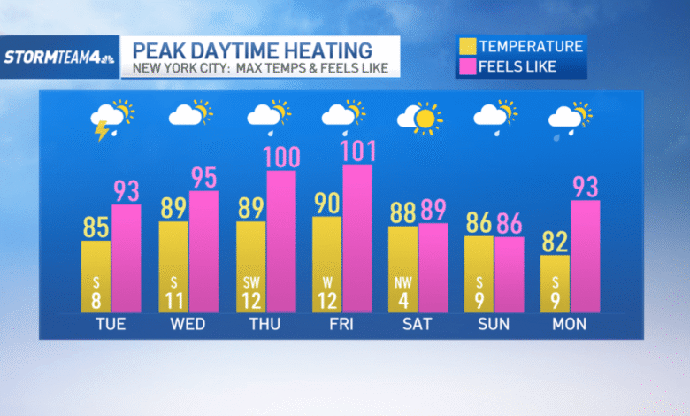
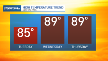
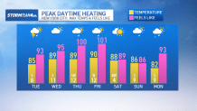
After starting the week in the mid-80s, we’ll steadily watch temperatures climb into the upper 80s and low 90s as we head toward Friday. Average high temperatures for mid-July are around 85 degrees; every day for the rest of this week is expected to bring above average temperatures.
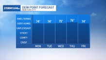
Of course, the air temperatures are only half the story. The other half is the humidity. Our dew points, the measure of total moisture in the atmosphere, will be in the low to mid 70s the entire week. Any time dew points get into the mid-60s in the summer, it starts to feel uncomfortable. By 70, it’s unpleasant. And by the mid-70s it is miserable and oppressive.
These elevated dew points will also lead to some sweltering feels-like temperatures.
While air temperatures in the city are going to top out around 90 degrees, feels-like temperatures will approach the triple digits for the latter half of the week. This level of heat is dangerous; it is important to stay hydrated and limit prolonged periods of physical activity outside.
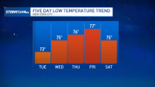
And part of what will make this week’s heat even more taxing is just how humid and mild we are going to stay overnight. Low temperatures all week are holding in the mid to upper 70s; that’s a good 5 to 10 degrees warmer than average July lows. These warm overnight temperatures mean we are not getting any opportunity to cool off, increasing the stress that this type of heat can inflict on the body.
But there is some good news heading into the weekend. A front passing through on Friday will dry us out a little. Dew points will drop back into the mid-60s briefly and we’ll even manage a day free of rain.
Unfortunately, it does not last long. Humidity starts to creep back up again by the end of the weekend as our next storm chance approaches. But this round of storms looks to finally help wipe us clean of that oppressive humidity, ushering in a more comfortable feel for the first half of next week.